
Lafleche point to Crockett's hole in West Bay of Lake Nipissing
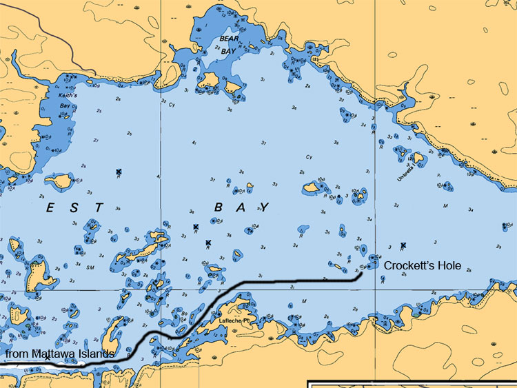
Crockett Hole, so named after the person that made this area is favorite fishing hole, is basically an area with small islands, nice rock shoals and boulders. This spot is awesome for Walleyes and Northern Pike in the earlier spring. Be careful when you enter this area as the rock shoals are barely submerged during normal water levels. Be versatile and fish the entire area. Concentrate on the submerged shoal at the tip of the west most island of Crockett Hole.
Map Legend:
Depth are in meters (ex 6.4 or 8 or5.2, the larger number represents main value the second represents the decimal value)
Tan (gold or yellow) represents Land. Dark Blue shallow water 2 meters or less. Light Blue represents waters between 2 to 5 meters. White represents waters 5 meters or more in depth
Anywhere on the map you see (05) or (0) is a shallow area or rocky area
All stars or plus sign with 4 dots indicates submerges rocks
The R attributed with a depth value means rocks submerged at represented depth
Ideal Time of Year to Fish West Arm of Lake Nipissing
Walleye: From opening in mid May to Mid August
Northern Pike: From opening in mid May to closing mid October
Bass (largemouth and small mouth): From its opening 3rd Saturday in May to mid September
Musky: From its opening in mid June to end July and Mid September to end of October
Fishing Areas & Maps
Let's breakdown the West Bay into fishing areas, describe them and tell you where and how to fish these honey holes.