
Keith's Bay to Bear Bay in West Bay of Lake Nipissing
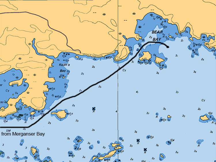
As you keep traveling to the northeast of Keith's Bay you will come up on Bear Bay. This bay is also fairly huge and offers numerous areas to fish. Some of the biggest Walleye catches have been experienced in this bay. This bay also offers deeper and shallow areas along with various shoals. The route to get there from Keith’s Bay is clear sailing but beware as you approach the island in front of the bay as a huge sunken shoal protrudes away from the shore. If you can safely find this shoal work it from all sides, as this area can be very productive.
Map Legend:
Depth are in meters (ex 6.4 or 8 or5.2, the larger number represents main value the second represents the decimal value)
Tan (gold or yellow) represents Land. Dark Blue shallow water 2 meters or less. Light Blue represents waters between 2 to 5 meters. White represents waters 5 meters or more in depth
Anywhere on the map you see (05) or (0) is a shallow area or rocky area
All stars or plus sign with 4 dots indicates submerges rocks
The R attributed with a depth value means rocks submerged at represented depth
Ideal Time of Year to Fish West Arm of Lake Nipissing
Walleye: From opening in mid May to Mid August
Northern Pike: From opening in mid May to closing mid October
Bass (largemouth and small mouth): From its opening 3rd Saturday in May to mid September
Musky: From its opening in mid June to end July and Mid September to end of October
Fishing Areas & Maps
Let's breakdown the West Bay into fishing areas, describe them and tell you where and how to fish these honey holes.