
German's Bay to South Muskrat in West Bay of Lake Nipissing
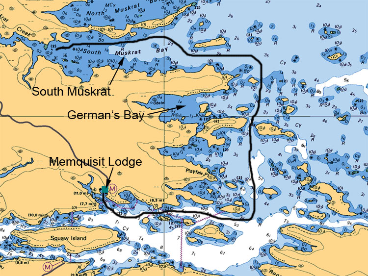
South Muskrat in West Bay of Lake Nipissing has been one of the favorite fishing areas for many anglers since it offers multiple fish holding areas. Although the route to get to South Muskrat is a little challenging, the bay itself offers a lot of rock shoals mostly near the shorelines with two large slightly submerged rock in the middle at the mouth and at the most west end at the mouth of Muskrat Creek. The bay offers excellent fishing for Walleyes, Northern Pike, Musky, Jumbo Perch, Small and Large Mouth Bass.
Map Legend:
Depth are in meters (ex 6.4 or 8 or5.2, the larger number represents main value the second represents the decimal value)
Tan (gold or yellow) represents Land. Dark Blue shallow water 2 meters or less. Light Blue represents waters between 2 to 5 meters. White represents waters 5 meters or more in depth
Anywhere on the map you see (05) or (0) is a shallow area or rocky area
All stars or plus sign with 4 dots indicates submerges rocks
The R attributed with a depth value means rocks submerged at represented depth
Ideal Time of Year to Fish West Arm of Lake Nipissing
Walleye: From opening in mid May to Mid August
Northern Pike: From opening in mid May to closing mid October
Bass (largemouth and small mouth): From its opening 3rd Saturday in May to mid September
Musky: From its opening in mid June to end July and Mid September to end of October
Fishing Areas & Maps
Let's breakdown the West Bay into fishing areas, describe them and tell you where and how to fish these honey holes.